The Mystery of the Bloomfield Bridge
.")
Why is this bridge here?
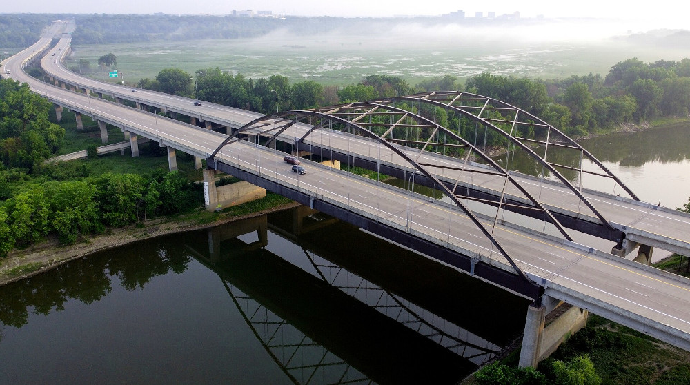
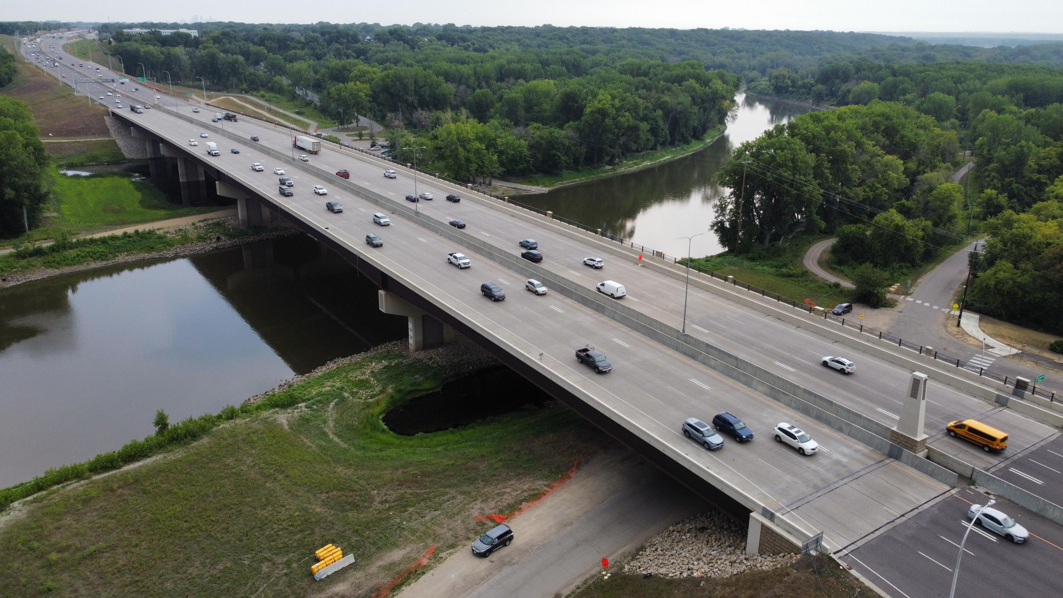
This pedestrian bridge crosses I-494 just west of the Minneapolis Airport. It connects Bloomington to Richfield. I drive under it often and I wondered: why is it there? It's not in an area that is particularly walkable, and it doesn't connect any establishments that obviously need to be connected. So why was it built?
I often have curious thoughts like this, but I dismiss most of them because if I answered all of them I would get nothing else done. But one day I was walking out of a Taco Bell and found myself at the base of the bridge.
")
That only raised MORE questions! Why did the bridge just lead to some grass? Why isn't there a sidewalk? What is the point? It makes no sense!
Obviously I had to walk across it to see where it went. I found that it connects that Taco Bell... to a Grainger.
It also connects a Super 8 Hotel to a Hertz Rental Car agency, which honestly makes a lot more sense. But as will become evident later in the article: those were not there when the bridge was built and are not why the bridge was constructed.
")
Grainger is an industrial supplier and the 11th largest e-commerce retailer in the world.
Source: While I was researching this bridge, D.G. Macpherson, the CEO of Grainger, spoke to a small group of us in Chicago and shared this statistic. That was quite the coincidence.
Instead of "retail," for this location you should think "warehouse with a front desk" (not really the kind of place you would need to walk to).
For the record: I am an advocate of walkability and pedestrian bridges. This one just stands out because it is in an area that is otherise not very walkable. If you gave me funding to make the area more walkable, I would build more sidewalks before I would build the bridge.
I went in an asked the folks at Grainger about the bridge. They said they didn't like the bridge! Their employees don't use it, their customers don't use it, and litter collects on their end of the bridge.
They also told me they don't eat at Taco Bell. They recommended a better Mexican restaurant on their side of the interstate.
I went home that day without an answer. But it kept bothering me, so that night I decided I would solve this mystery once and for all.
SEARCHING ONLINE
The internet is a good place to start. The bridge has a plaque that reads "Federal Aid Project FAI 494-4-32 Minnesota 1959."
")
So I tried searching for the project number.
Unfortunately, searches for Federal Aid Project 494-4-32 (or any iteration thereof) yields absolutely nothing. "494 bridge construction" is an even more useless search. There is a federal aid project records site, but it only goes back to 1992.
I never would have expected to learn so little from such an audacious plaque! Why even have the plaque if it doesn't link to anything?
WHAT WAS THERE BEFORE GRAINGER?
The project number isn't searchable, but perhaps the purpose will be obvious if we just look at photos of the area from when it was built.
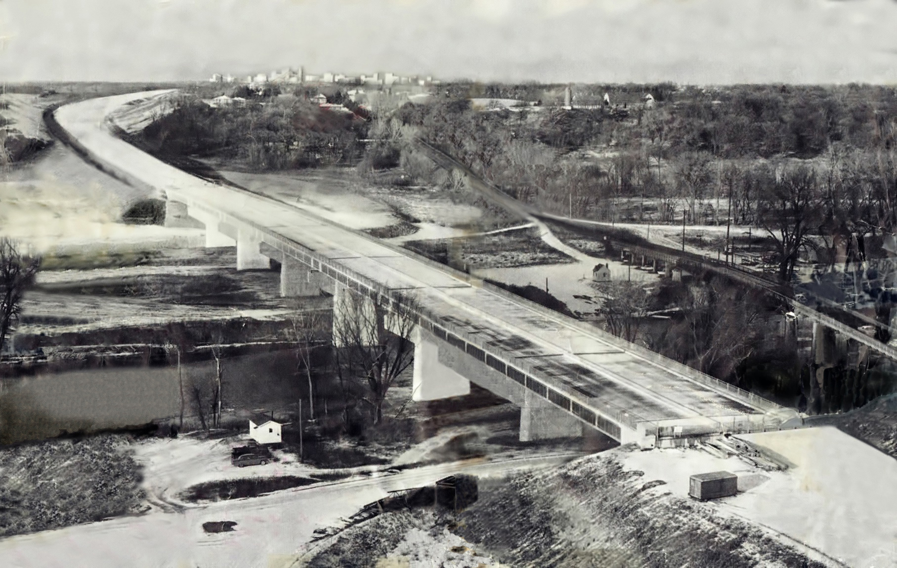
The good news is that there were aerial photos taken around that time. The confusing news is that, at the time of construction, the south side of the bridge (where Grainger is now) was just an empty field!
Here is an aerial photo with the bridge marked with a red arrow. Beneath the bridge you can see the empty lot.

Why would you build a pedestrian bridge to an empty field?! That makes even less sense. Yes there is a neighborhood south of the field, but if you are in that neighborhood surely you could just use the sidewalk on one of those other two bridges a few hundred feet to the east or west.
Sure it would be a long walk, but it wasn't clear to me what they would even be walking TO in the first place.
Why build the bridge?
LET'S ASK AROUND
Earlier I said that if you search "494 bridge construction" that you don't get useful results. That is not entirely true: you do find the I-494 Corridor Commission.

The I-494 corridor commission was formed by the cities located along its route. Its purpose is to address the terrible traffic on that stretch of freeway. They do this mostly by encouraging people not to drive on I-494. (Because you can't have traffic, if you don't have traffic.)
I sent a note to the Executive Director of the Commission, Melissa Madison.
When hearing this story, folks are sometimes surprised that I was able to get responses from so many people and government offices. I try to be courteous and specific in my emails; I find that people are usually happy to help when treated well. When possible (i.e., I did not submit the ask through a web form), I will include a copy of the asks I sent in these notes.
Here is the email I sent to Melissa:
Hi Melissa,
I found your email on the 494 Commuter Services website, and am hoping you can help me with an odd question.
I am hoping to learn more about a concrete pedestrian footbridge that crosses over 494. I drive under it regularly, and have been trying to figure out why it was built. The bridge in question is located over 494 at 2nd Ave S, just east of Nicollet Ave. It was built in 1960. However, its original purpose is not clear to me. As you can see in the attached arial photograph taken in 1966, the bridge seems to have originally led to an empty field on the south side. It doesn't seem to have led to anything!
Today there are business on both sides of the bridge, but this walkway does not appear to be the preferred method to cross 494 by foot in the area. The Nicollet bridge that is 400ft west is better maintained (in terms of surfacing), cleaner, and better lit. I imagine that the bridge is only still there because it is difficult to deconstruct a concrete bridge spanning over 494 - but this still leaves open the question of why it was built in the first place.
Would you happen to know anything about this bridge, or be able to direct me to an archive that may provide more information about its original construction?
I know you are busy and that this is low on your priority list to respond to, but I do appreciate any direction you can provide.
Cheers,
Tyler
I explained what I was researching (acknowledging that it was an... oddly specific topic) and asked whether she could provide me with any information about why the bridge was built.
Melissa got back to me quickly and was gracious with her time. She did not know why the bridge was there, but she very generously sent a few feelers out to city and state employees to see what information was available.
Melissa connected me to the Bloomington City Planning Manager, Glen Markegard. Glen didn't know of any specific reason why the bridge was there either. However, he pointed out that it was probably built in anticipation of future development. He said that a lot of infrastructure at that time was necessarily built in anticipation of future growth, and the empty field seemed to support that idea here.
Let's explore that theory!
STATE OF THE INTERSTATES IN 1959
1959 was the heyday of construction of the interstate system. A few years earlier, President Eisenhower decided there were too many bumps on the road to California (and was jealous of the Germans' ability to move military equipment around easily),
I state this parenthetically, but it is quite the story so I will re-recommend Big Roads by Earl Swift if reading about infrastructure is your thing.
so he signed the Federal-Aid Highway Act of 1956.

This act provided substantial federal funding to states if they would build interstate highways. The feds would pay up to 90% of the costs,
A lot of articles that I have read about this state the 90% federal funding as a hard fact and then move on. In reality it was more complex: core interstate projects built and approved at the right time could be funded at 90%, but in reality a lot of projects were considered 'primary routes' or 'secondary routes' or fell into some other category that received a lower share of funding. See this letter summarizing the pro-rata share in Minnesota at one point as an example:

There was a lot of back-and-forth negotiation about the ratios of funding for any individual project. Often the federal government chipped in only 50% of the cost, and you can see examples of other entities (like utility companies, counties, and cities) paying for portions of projects depending on what and where they were. I suspect this bridge was 90% funded by the federal government and 10% by the state of Minnesota, but I haven't actually found evidence to confirm that.
as long as the states covered the rest. But the impetus was on the states to plan and direct these roads, so if you wanted the money you had to figure out how to use it.
This is actually a deeper point than I am flippantly implying. A core principle of the planning of the interstate system was local use cases and direction. The metropolitan planning effort was truly directed by the states and local governments. There was broad federal direction to create alignment of the routes between states, but this is not very difficult because in general the connection points between most states are out in the middle of nowhere. Obviously there was a lot of fighting about which states interstates would go through, but by the time we are thinking about this bridge we are well past the point of agreement that two interstates (I-35 and I-94) will be converging in Minneapolis.
If you read newspaper articles from that time period (and believe me, I have now read many), you will find a political atmosphere that demanded moving quickly to use those federal funds to build the interstate system.
Minnesota was in a particularly difficult situation. Its neighbors had an advantage: it is relatively easy to build interstates in North Dakota or Iowa where you are mostly taking over strips of farmland. In contrast, it is difficult to evict the tens of thousands of people necessary to build interstates through Minneapolis.
Thus, the speed of interstate construction was a hot political topic. See for example this article in the Minneapolis Star from 1960.
This is from the Minneapolis Star in 1960. If you are from the area, you will recognize the Minneapolis Star as one half of what is now the Star Tribune. This article is from before it merged with the Minneapolis Daily Tribune.

Politicians had a lot of incentive to move quickly to plan and construct the interstate. They had funds to spare and need to stand up works programs to keep folks employed.
I have lightly glossed over the fact that a lot of these decisions were basically a form of social welfare to ensure strong employment among the lower classes. But again, that doesn't tell us why the bridge is there, it just tells us that there was an atmosphere that made it easy to build bridges in general.
Combine this with the high growth in the Richfield area at the time and the anticipation of future development, and you have substantial fuel to expedite decision-making. Perhaps they just were building fast and making decisions quickly and there was no real reason for the bridge.
Well, I am willing to accept that the bar was low for deciding to build a bridge. But I am not willing to accept that there was no reason for the bridge to be built there. They could have placed it a mile down one way or the other. If it was just 'because,' why not somewhere else?
ASIDE: WHY DO WE CARE ABOUT THIS BRIDGE AGAIN?
It is at about this point in the story that whoever is enduring hearing about it from me inevitably asks: "Hold on, why do we care about this bridge so much?" Which, yes, fair question.
Up until this point, it was curiosity. From here on out though, it is stubbornness.
I don't understand why this question is so difficult to answer. There IS a reason that bridge was built, and by golly I am going to find it! Will it be a bribe from a local business? A conspiracy with the construction company? An ordinance that requires a bridge every 5 miles? A makeshift deer crossing built by the DNR? Someone accidentally copy-pasted a bridge when playing Cities: Skylines of Minnesota?
Whatever it is, I want to know!
IS IT A REGULATION?
Many people I discussed this with suggested there could be a law requiring a minimum number of pedestrian bridge crossings per XX miles of interstate. We should not rule this out too quickly. After all, while the 1960s is the era of cars, bicyclists were a loud voice advocating for road improvements and standards at the beginning of the 20th century (you can read more about this in the early chapters of The Big Roads by Earl Swift). Perhaps there was a vocal group that got a law signed.
But of course, bicycle advocacy probably doesn't apply to the bridge in question, as it has stairs—which are not known for being conducive to bicyclists.
Edit: I was wrong! I later learned that these stairs were specially designed to accomodate bicycles! Learn more in this note:
After I published this, many people emailed me to say that they used the bridge to cross I-494 with their bikes, and that they appreciated the ramp it had for bicycles. When I crossed the bridge I did not notice: it has ramps on both sides that are the width of bicycle tires so that you can push your bike up the stairs.
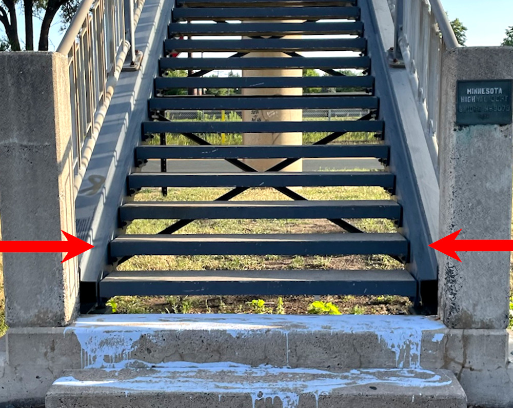
At first I thought that was just an artifact of construction. To me it does not look like it was really intended for bicycle use, but more like a happy accident that is handy for bicyclists. But then I was wrong again! One reader, Jason Hall, helpfully pointed out that this little 4-inch flat ramp was explicitly labeled a bicycle ramp in the original engineering plans:
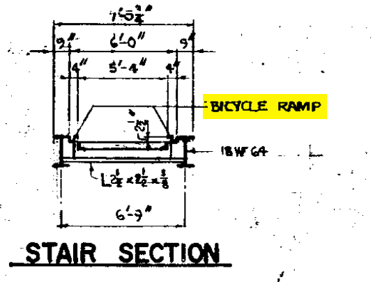
How cool is that! Perhaps not the epitome of bike-friendly, and still not helpful for those in wheelchairs or who might otherwise find difficulty with stairs, but at least they did think of kids pushing bikes.
.")
In my research, I have found no law or regulation that requires a certain number of pedestrian or bicycle bridges to be built over interstates. There will be regulations relating to stairs, because that bridge is definitely not ADA-compliant. But those laws won't gain momentum until the 1980s culminating in the Americans with Disabilities Act of 1990.
Also: there are clearly thousands of miles of interstate highways across the country in rural areas with no pedestrian bridges (source: just drive down any interstate outside of a metro area). On the entire 42-mile stretch of interstate 494, there is only one other pedestrian footbridge that was built during the same period. So no dice on a law.
Even if there was a guideline as to where to build bridges (and we'll explore one in a bit), we would expect discretion as to where the bridge is built. If so, we can ask why this specific site was chosen.
MnDOT MAINTAINS IT; LET'S ASK THEM
Highways in Minnesota are maintained by MnDOT. They have a handy interactive bridge map that shows all of the bridges in the state. And there are a LOT of bridges.

They even have detailed maintenance records available. The site indicates that the bridge we care about is bridge #9078. But unless you are interested in an empty hydraulics report, these reports tell you very little.

However, they do have contact information. So I wrote to the Bridges Division of the Minnesota Department of Transportation.
Here is the email I sent to MnDOT:
Hello,
I am a resident of Bloomington seeking information about MNDOT Bridge #9078. This is a concrete pedestrian footbridge located over 494 at 2nd Ave S.
The bridge was built in 1960. However, its original purpose is not clear to me. As you can see in the attached arial photograph taken in 1966, the bridge seems to have originally led to an empty field on the south side. I would like to understand why it was originally constructed.
Could you kindly direct me to any original proposals or construction plans for this area of 494 in the 1950s that may outline the purpose of this bridge?
Today there are business on both sides of the bridge, but this walkway does not appear to be the preferred method to cross 494 by foot in the area. The Nicollet bridge that is 400ft west is better maintained (in terms of surfacing), cleaner, and better lit. I imagine that the bridge is only still there because it is difficult to deconstruct a concrete bridge spanning over 494 - but this still leaves open the question of why it was built in the first place.
Thank you in advance for any direction you can provide.
Cheers,
Tyler
I shared what I was researching (again acknowledging that this was an... oddly specific topic) and asked them if they could kindly share any information about the bridge or its original construction plans.
Peter Wilson of the Bridges Division got back to me very quickly.
This is an understatement. I sent an email to the the Department of Transportation at 11:00PM on Wednesday and Peter responded at 7:48AM on Thursday, which is ZERO BUSINESS HOURS later. This is the fastest response to a data request I have ever received.
He provided the original engineering plans as well as photos of the bridge taken shortly after construction!
Let's look at the engineering plans first:

These thoroughly describe how the bridge was built. It names many of the people and companies involved in building the bridge, like Walter Butler Co. It does not, however, explain WHY the bridge was built here.
There is a signature block and additional project numbers:

I tried looking up these project numbers, but to no avail.
In addition to searching online, I also looked them up in physical archives at the Minnesota History Center. Nothing there either.
I also looked up the people who are named in the document. Because they signed their names, this was not the easiest of tasks, but I did make some out.
Unfortunately all I found were obituaries. Anyone of age to make decisions about building bridges (i.e., 30-50 years old) in 1959 would be between 90 and 110 today. More directly: everyone involved in designing this bridge is now dead.
When I share this as part of the story, some folks ask me if I looked up their living relatives. The short answer is: yes, I started, but I realized that that approach made no sense. What was I going to do, send someone a LinkedIn message request and ask "hey do you know why your late grandpa built this specific pedestrian bridge?"
The engineering company was Walter Butler Co. The Butler family owned a large construction and engineering design company that benefited from being in the right place at the right time during a boom in growth in Minnesota and the construction of the interstates.
We could do an entire article about how you can trace many race-based socio-economic advantages and disadvantages back to the fact that during this growth period in America, all companies that were 'in the right place at the right time' were white-owned. But this article already has too small of a scroll bar, so that will have to wait for another time.
However, most legacy information about the Butler family and their companies dates back to the 1800s, which is too early to apply to the bridge.
Now let's look at the photographs MnDOT provided. First is a side view, where the photographer is standing where Grainger is located today and looking northwest:

")
Not much about the bridge has changed! But there is also not much to learn from that photo. Here is the other one:

In the foreground is that empty field, which tells us nothing new. But in the background is a thrift store—that's new! The small signs on the ground say "FAST! SAVE! POWER!
POWER! isn't an intuitive marketing slogan to me, so I did a little digging. It turns out Atlantic Mills' slogan was 'where your pennies pack POWER!' so that's why it's on the sign. (Look, I was desperate for clues.)
FAST!" The large sign on the left says "Atlantic Mills Thrift Center." Maybe the thrift store lobbied for or funded a pedestrian bridge to their store.
I have family from this area, so I sent a few text messages asking grandparents if they were familiar with Atlantic Mills.
My family is from the next county over, which is why I didn't start there. But a large store might attract people from a little further away than, you know, a pedestrian bridge.
My grandmother was familiar with it, but only remembered that "it had very good sales!"
My grandmother's priorities in life are (1) Elvis Presley, (2) her grandkids, and (3) good sales; so this input from her tracks.
She only ever drove to the store though, so no support for why the pedestrian bridge would be useful.
The next place to search for the store is in old newspapers. I had previously tried searching for iterations of "494," "78th street,"
78th St is the name of the street that used to be where I-494 is now. Fun fact if you are from Minnesota: the street numbers (not the avenue numbers) that start in Minneapolis near the river (e.g., 3rd St.) continue down all the way through the south suburbs, down to Elko New Market (260th Street). You can look at any road map and just keep counting up the numbers. I-494 was 78th Street before it got the interstate number; now the frontage road is 78th Street to keep up the pattern.
and "pedestrian bridge" in newspaper archive services, but these don't yield very helpful results.
The problem is that searching for numbers (494, 78th) in a newspaper archive mostly pulls up prices, phone numbers, addresses on wanted ads, and page numbers. For example, here is the first result when you search "494":
Not helpful!
But searching for Atlantic Mills does yield results. I found an article that indicated that the location for that store was being decided in 1959, the year the bridge was built!

According to the article, the location of the thrift store location was not yet finalized in February of 1959. We can cross-reference that date with the dates from the engineering plans MnDOT shared with me. The cover sheet specifies the plans for the bridge were approved in 1958:

And the certification stamp on the site survey on a later page is dated to October of 1955:

That means the planning for the bridge started at least 3 years before the Atlantic Mills thrift store location was finalized. Thus, it is unlikely that the thrift store influenced the location of the bridge—if anything, the inverse may be true.
WHAT HAVE I MISSED? OLD MAPS WILL TELL
At this point I had exhausted all my active leads. So I went back to the collection of aerial photos and maps from the area from the 1800s and 1900s. After flipping though a few, I found two interesting things.
First, the area around where the bridge will be built was called "Bloomfield." I've indicated the place where the bridge will be built on this small section of a USGS map from 1896:

The name "Bloomfield" appears on maps at that spot from the late 1800s all the way up until the 1950s, when it disappears. No one calls that place "Bloomfield" today.
Source: I live here and no one I know calls it that. It also doesn't show up on any maps or in any newspapers today.
Minnesota does have a township named Bloomfield, but that one is down in southeastern Minnesota, 120 miles away.
However, the area labeled Bloomfield on this map refers to the area between what is now Bloomington and Richfield, which can't be a coincidence... right?
Narrator: "It was not a coincidence."
We will come back to this later.
The other thing I found was a more immediately promising lead. On this 1954 map from the US Department of the Interior, I found a prominent label for "Assumption Sch." just north where the bridge will be built. I've indicated the future location of the bridge with a red arrow here:

Now THAT is a lead!! If "sch" is short for "school,"
Spoiler: yes, obviously 'sch' is short for 'school.'
then that's a great contender for a reason to build a bridge!
ASSUMPTION CHURCH AND SCHOOL
This building is still there; it is the Church of the Assumption of Mary in Richfield.
.")
I hadn't noticed it before because the church itself is set back from the interstate behind a row of trees. The distance is in part due to the church's cemetery, which sits between the church and the interstate.
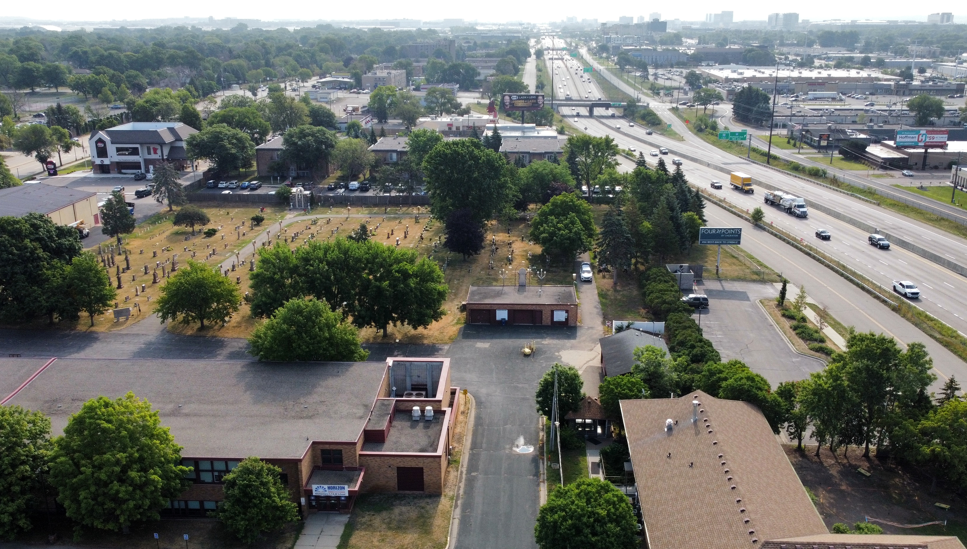
In fact, it appears that the entire interstate itself was curved to avoid the cemetery. You can see that curve away from the cemetery in this drone shot, which shows the Assumption Cemetery on the left and I-494 on the right, looking east toward the airport:
(I'll let you imagine the paperwork I had to do in order to get approval from the FAA to allow me to fly a drone near an airport to get these photos.)
Interstate construction requires a significant amount of grading on either side of the road, so it makes sense that you would want distance between the interstate and a cemetery (you don't want to accidentally dig up corpses). This is especially important for the Assumption Cemetery, because not all the graves have markers. I know this because I spoke with one of the first female Eagle Scouts in Minnesota, Therese Phan. In 2022 she did an entire project marking graves in the cemetery, and described the unmarked sites. Thanks Therese!
I also found the original quitclaim concessions from property owners who gave up land for the interstate at this spot. I was researching quitclaims to better understand who owned the property around the bridge. But the description of these curves where the road is not perfectly straight are hilariously complicated and specific. They can best be described in traditional Minnesotan as 'oofta doofta:'
If you couldn't tell, this was a very deep rabbit hole that I went down. Ultimately this research path did not lead to any insights about the bridge. But hey, at least that is more content for the in-line notes!
The red arrow below points to the church, as viewed from the bridge.
.")
The website for the church includes a history section. Jackpot!
The church was originally built in the 1800s, but grew with the community in the 1900s. The school in the church served a large number of children in the community, peaking in attendance at 1,170 students in 1959-1961, right when the bridge was built!
What a find! The desire paths that we saw on the aerial photo earlier through the empty lot would track with kids walking from that neighborhood over the bridge to go to school.
I reached out the to church and asked if they would be kind enough to provide my contact information to anyone in their parish who lived in the area in the 1950s or 1960s and would be open to speaking with me.
I did not send an email for this one because they had a web-based contact form on their website. I kept it short and sweet. In order to encourage a reply, I included my name, email, phone number, and home address in the request.
Ann Anton's story
The next day I received a call from Ann Anton. Ann was born in 1948, so she was 75 years old when I spoke with her. Her family moved to Richfield in the 1950s and still lives there today. Here's a photo of Ann in front of her house in 1969:

Ann attended school at Assumption in 6th, 7th, and 8th grades. She lived on the north side of the bridge, so she didn't need to take the bridge regularly. But she knew many kids who did! She said it was certainly used by the schoolchildren at Assumption School. She described often running across the bridge as a child.
I had read that Assumption Church was a pillar of the growing community in the 1950s and 1960s. Ann confirmed this: she said it was the "hub of social activity in the area." It was so packed that the congregation came together to build an Activities building, with funding acquired by assembling hundreds of community members to be the "broom brigade" for the Met Stadium, which was located where the Mall of America is today.
Ann told me it was hard to overstate how homogeneous the area was. All the families were the same age, and they were all white, and they all were the same economic class, and they all had the same backgrounds (most of the dads were WW2 vets). They all had a bunch of kids at the same time. She described the "baby boom" more acutely than I had ever heard it described before. For her, it was a "swarm of hundreds of kids" the exact same age.
Ann was very thoughtful. She pointed out that while she enjoyed her upbringing, she missed out on interacting with a more diverse community in her childhood. She was grateful for the exposure to a much different community now (the community is now so prominently Hispanic that a third of the services at the church are held in Spanish).
Ann's mother is Florence Simon, and she was at one point the Principal of Assumption School! Florence is also still alive, at 99 years old(!) when I spoke with her. But she did not recall the bridge, nor being consulted about the construction of the interstate.
Interestingly, she was consulted about the construction of Best Buy's corporate headquarters nearby. But who cares about that? I only want to know about pedestrian bridges.
Ann also couldn't say for sure why the bridge was originally built (no one consulted 10-year-old Ann), but she did "strongly suspect" the school was the reason.
This is promising support for the theory that the bridge was built to go to the school! But now that I am this deep, I want hard evidence. Let's keep looking.
OTHER MINNESOTA INTERSTATE RESEARCH AND HISTORY PROJECTS
If you do enough searching about the construction of pedestrian bridges over interstates in Minnesota,
This is a very common and completely normal research topic, after all.
you will eventually come upon these three sources:
- Politics and Freeways: Building the Twin Cities Interstate System by Patricia Cavanaugh, which shares a detailed 136-page account of the politics and decisions for building the interstates in Minnesota
- Streets.mn, an unofficial but helpful (and opinionated
This is a good thing in this context. Opinions are often better than official records at answering questions that start with 'why.'
) site that provides various histories and insights into road-building in Minnesota - A public history of 35W, which details the human toll building the interstates took on local communities—particularly Black communities near Minneapolis and St. Paul, which were uprooted to make way for the interstates
I am not doing this topic justice here; I would encourage you to check out this project if you are not familiar with it.
The three sources are valuable in their own ways, but they all gloss over the construction of Interstate 494. Compared to its peers, this section of the interstate was uncontroversial, simple to acquire,
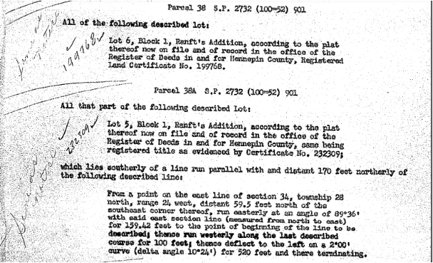
In Minneapolis and St. Paul they evicted tens of thousands of tenants with little recourse. In Bloomington and Richfield to build 494, most of the land rights releases I found were quitclaim deeds for $1 for small portions at the edges of lots.
For example, this is from the lot on the North side of the bridge where Taco Bell and Hertz are now:
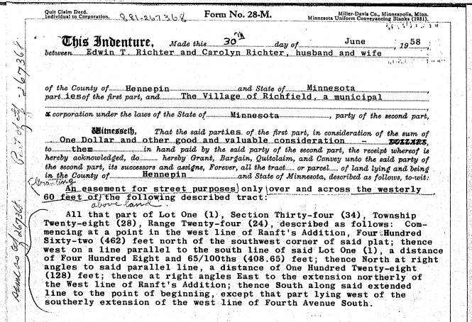
I had to do a LOT of digging to figure out the right lot, section, and range for this spot in 1958, and then I had to request (and pay for) these transfer records from Hennepin County. I was hoping to find some link that showed the property owners were willing to give up their land for the nominal fee in part because the state agreed to build a bridge, but I never found direct proof of that.
and among the fastest to plan and build.
However, all three sources frequently mention one key planning report from the time: a report written by George Barton titled "Freeways in Minneapolis" published in 1957.
Many other sources also pointed to the Barton Report, including newspaper articles from that time and opinion pieces debating the locations of the freeways. I knew I needed to read this report.
THE BARTON REPORT
The Barton report was commissioned by Minneapolis to determine where the interstates should be constructed. Unfortunately, I could not find a digital copy of the Barton Report online. Thankfully: the Minnesota Historical Society maintains an original paper copy of the report. So I went up to St. Paul to review it for myself.
It may not surprise you to learn that my wedding took place in the main hall of the Minnesota History Center, which is three floors above where this document was stored.
The Barton report does not cover I-494.
The report was focused on the interstates near Minneapolis, particularly 35W and 94. This makes sense given the report was commissioned by the city of Minneapolis and not the State of Minnesota. I was hoping that it might cover 494 because at the time there was an open question about whether Richfield would be annexed by Minneapolis.
While the report does not directly cover 494, it was still a very influential report, and paved the way (pun intended) for Barton to do similar work in other states—so I would not discount the likelihood that the themes and general recommendations it contained were applicable elsewhere in the state (like, say, pedestrian bridges over 494).
But it does provide a lot of insight into how planners thought about interstate construction at the time. The most relevant page in the Barton report is this one, which specifically recommends building overpass walkways near churches and schools.

That is the most direct supporting evidence we have seen so far to indicate that a pedestrian bridge over an interstate near a school may have been primarily built for the purpose of enabling students to walk to that school! It seems increasingly likely that Assumption School is the reason for the bridge.
I know that at this point it really feels like the school is the answer. But I wanted to be careful about being too presumptuous. I was ready to accept that the bridge was basically just a random works project like 80 paragraphs ago! I can't take 'most likely' for an answer anymore.
Also: I am having fun turning over rocks, because each branching research path has had so many interesting adjacent facts to find.
HISTORICAL RECORD REVIEW
Since I was already at the History Center,
Just kidding: I made multiple trips.
I asked the staff to pull every other record on interstate planning, federal aid projects, and the Minnesota Highway Department that could possibly be related to Interstate 494 or bridge construction. Bless the Historical Society staff and their patience to go down into the archives to pull boxes for me.
If you've never been to a reading room at an archive like this: it's a bit different from the library settings you are used to. The artifacts and historic documents are stored in underground warehouses of endless rows of boxes, but you are not allowed down there. You have to request archives to be pulled on your behalf. You sit in a reading room at a table actively monitored by staff to ensure you don't damage, destroy, or steal records. Usually you are not allowed to bring bags, food, drinks, or pens; sometimes you are not even allowed to bring your own paper.
.")
I reviewed many records from state and county agencies from the 1950s and 1960s. I learned all about apportionments and contracting for the interstates in Minnesota. And I probably caught some weird diseases flipping through so much dusty old paperwork.
I learned to wear a mask when going through old documents. Even if it doesn't have any diseases, I seem to be allergic to 1960s dust.
.")
I went through the Highway Department project files,
Reference: 200832-10
Federal Aid files,
Reference: 103.C.12.3B
bridge correspondence,
Reference: 103.C.12.2F
and county commissioner correspondence,
Reference: 117.I.1.10F
. I even read through a tome of annual reports from the Hennepin County Highway Department.
Most of them were typed, but some of them were handwritten, like this record of individual bridges:

I don't think you will mind taking my word for it: I exhausted all the official records at the Minnesota Historical Society and found no additional information about bridge #9078.
THE SCHOOL REPORT
The most surprisingly useful document I reviewed was not a government record at all. It was a history report written by a 9th grader named Howard Kyllo in 1951:
The document doesn't have a date; I am just estimating based on his obituary and the age students usually are when they are in 9th grade.

Howard wrote this as a school assignment, and it somehow found its way into the stacks of the historical society. I enjoyed the whole thing. In his paper, Howard answers a question that we posed way back when we looked at the maps of the area from the 1800s.

Remember that map with "Bloomfield" on it? The area was called Bloomfield because of the church, and it got that name because of the close connection between Bloomington and Richfield!
I know this sounds a bit old and trivial, but bear with me for a second. There was such a close community connection between both sides of that interstate when they built the church that they went to the trouble of concatenating the names of the cities to showcase the connection. What could be more apropos than a pedestrian bridge reconnecting the two communities at the site of Bloomfield?
For what it is worth, I am glad they chose Bloomfield instead of the alternative: Richington.
However, Howard the 9th grader did not do a good job of citing his sources,
I suspect he didn't cite sources because he was just asking older members of the community for history. He didn't have Wikipedia, and there are no textbooks available with this information, so I don't know what sources he could have cited. I also suspect this is why someone bothered to archive his project, but I have no proof of any of this.
so I went looking for another primary source to back up Howard's bold claim.
Sure enough, documents recording the history of Assumption Church buttress the Bloomfield fact:

Valentine Haeg donated more than anyone else to the founding of the church. He lived in Bloomington, so as a compromise for building the church in Richfield, the community agreed to rename the area "Bloomfield."
If you weren't convinced that Valentine really cares about names: the original church was named St. Valentine (ostensibly after the saint, but come on). They renamed it to Assumption after it burned down and was rebuilt. This is why I am pointing my finger at Valentine Haeg specifically (but this is conjecture).
I have to say: I am now of the opinion that more 9th grade history reports should be retained in historical archives.
ORAL HISTORIES & COMMUNITY DOCUMENTS
Another fantastic source of historic information about the area is the Minnesota's Greatest Generation Oral History Project.

This is one of the coolest history projects I have ever found. It is dozens of interviews conducted by historians with community members from the Greatest Generation (born 1901 to 1927) to record their experiences of historical events (and mundane life).
I learned a lot from these records! One important fact: local residents referred to what is now I-494 as the "beltline."
One unimportant fact: the beltline originally had 3 lanes: one eastbound, one westbound, and one in the middle for passing. The passing lane was called the 'suicide lane.'
We discussed previously the importance of good keywords when searching newspaper archives. Well, "beltline" is an excellent keyword! Far superior to "494" or "78th street" or "footbridge." By using "beltline" as a search term, I was able to find the following article from the Minneapolis Star which mentions a community hearing on the plan for the super beltline:

That article was published on Tuesday, March 1, 1955. The Richfield City website does not post records that go back to the 1960s. However, to no one's surprise, I reached out to the city and asked if they had minutes from the city council meetings on Monday, February 28, 1955 and Thursday, March 3, 1955 (the dates referenced in the article above).
And they had them! Dustin Leslie, the City Clerk for the City of Richfield, was kind enough to provide copies of the minutes from both of these meetings. Unfortunately, the minutes only say that the topic of the interstate came up and that "a discussion followed."
The hearing that was held later that week on March 3rd had more detail about property owners and business owners who opposed the highway improvement plan. You can read the document below, or click on it if you would like to see the full PDF. It doesn't say anything about the bridge, but does provide some leads on who is participating in the discussions about the plans for the interstate.
I figured some of these people might have been the ones to push for a bridge. However, I don't think that they did, as they are mostly business owners who would be negatively impacted, and their properties are not near the pedestrian bridge. Regardless, when I pursued this investigative path I did not find any evidence to support the reason for the bridge.
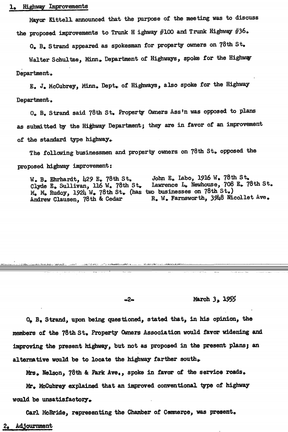
I highlight the February 28 minutes in the main flow of this article only because it is a simpler representation of what I found, which is nothing. 😊
 you want to read the full minutes.")
In the context of these minutes, Highway 100 refers to I-494/78th street/the beltline. If you are from the area you may know Highway 100 as a road that runs north-south through Edina and St. Louis Park. There's a whole story about this that we are not going to get into right now because we have a bridge mystery to solve.
Highway 100 was originally a U-shape around the metro, not just a north-south road like it runs today. It got the cool number (100) because it was meant to be a very central, primary highway.
This section of road was also Highway 52 at one point. (The same road having so many different names makes it difficult to research.) Here is a photo that was taken from Highway 52 in 1926 of Lyndale bridge that MnDOT was kind enough to provide from their records:

There wasn't much there! One striking thing to me is way off in the distance on the right side: the shape of those high-voltage power lines. That is what they look like today too! I would have assumed construction of high-voltage lines of that size and shape were a more recent feature, but it seems they are over 100 years old! Perhaps a topic for another time...
I read every other article from the Minneapolis Star that comes up when searching for "beltline" with no luck. I also read all the available issues of another newspaper, the Bloomington Sun, that were published in 1959. These aren't digitized, so I couldn't search them. Instead I skimmed all the issues on microfilm.
To keep my optometrist employed.
I'll spare you the details: I did not find anything else about the bridge.
I did find a front-page article with a photo of the demolition of the old Lyndale bridge just west of our bridge, which was cool!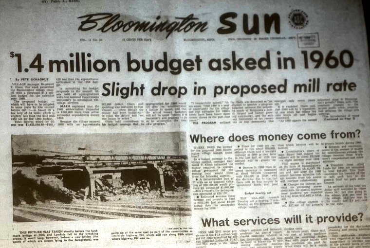
OK, we have thoroughly exhausted historical records in Minnesota. Let's take another approach to gathering evidence.
OTHER PEDESTRIAN BRIDGES IN THE TWIN CITIES
One technique we have not used yet is just looking at other pedestrian bridges in the area. Those might give us some indication of why the walkways are built generally and therefore provide some insight into why this one was built.
To do this we need to establish a baseline inventory of bridges. Specifically I am interested in bridges built around the same time as the interstates in Minnesota: in the 1950s, 60s, and 70s.
I am not as interested in bridges built after the 1980s and 1990s because I find that they tend to be built for a different set of purposes than the ones build with their interstates in the 50s, 60s, and 70s. Specifically the bridges built more recently tend to be for things like bike trails or long hiking trails and less so for connecting local communities. These more recent use cases make perfect sense when you think about it. If you are building a pedestrian bridge long after the interstate has already been constructed, you would not be doing it to maintain a community connection. The two communities would have grown separately, as the interstate itself forms a barrier between them. This is a central premise of the 35W Human Toll work.
MnDOT has an inventory of bridges that we explored before, but it turned out not to be a good source.
MnDOT's data is limited to bridges that are still standing, which isn't a filter I want. It also defines 'year built' by the most recent year available, which is a later year if the bridge was rebuilt or remodeled. (For example: the 24th Street Bridge). These two challenges, combined with the fact that MnDOT doesn't actually have a filter for pedestrian bridges in the first place, led me to set aside that database as my source of truth.
Instead I assessed aerial photographs taken of all the interstates shortly after they were constructed.
I didn't stick to a single year across the metro because the interstates were built piece by piece from 1950 all the way into the 1980s. By the time the 1980s rolled around, some of the bridges from the '50s were already being remodeled or demolished. Thus, I generally went for the aerial photographs that were taken as early as possible after the interstate I was reviewing was completed.
The aerial photos look like this:

That section is another part of I-494. And that red arrow I added points to the only other pedestrian bridge built during that time over I-494. It also led to a church that was also a school: the Immaculate Heart of Mary Parish. I think we are on to something with this school/church thing!
For good measure, I reviewed aerial photographs of all the interstates, US routes, and major state highways in the Twin Cities to identify pedestrian bridges.
Believe it or not, I was specifically trained by the military as a geo-spatial analyst to identify bridges in black and white aerial photographs taken in the 1960s. The training was on Russian bridges with decidedly more strategic utility than these pedestrian bridges, but the same principles apply: size, shape, shade, shadow, surroundings!
In total I manually scanned 300 miles worth of highways.
I only included the metro area, which means excluding pedestrian bridges in Duluth that go to the harbor (for example). I also am intentionally excluding the most iconic pedestrian bridges in the Twin Cities: the skyway system. The skyways are interesting in their own right, but they do not cross highways and generally are built and maintained by the property owners they connect, so the situations are very different.
I found 31 pedestrian bridges, of which 23 (74%) connected to a church or school. That's a strong statistic!
There is a bit of an art to deciding whether it 'connects' a school or church, because they won't always be right at the end of the bridge. This is my best guess, but you can go look at 300 miles of roadway and make your own estimate if you'd like to pressure-test my answer.
.")
(You can explore the full map or download the spreadsheet, in case you are really into maps and spreadsheets like me.)
Most of the pedestrian bridges that do not lead to a church or a school connect to a park or hospital. There are two that seem to just connect neighborhoods for no other reason. If anything, this just made me more curious about why THOSE bridges were built—but let's not get distracted.
Well, maybe too late for that. But at least let's focus on one distraction.
WHAT ABOUT THAT FEDERAL PROJECT NUMBER?
We have a very good working set of circumstantial evidence. But it sure would be nice to find some direct evidence. We exhausted all the evidence from the state and county, but what about the feds?
I went back to that federal project number from the plaque on the bridge that yielded no results when searching (494-4-32). Someone would have had to submit a proposal for those federal funds, right? The federal government has a website that tracks federal aid projects, but as I mentioned earlier it only goes back to 1992.

I tried writing to the St. Paul office of the Federal Highway Administration, but had no luck getting a response. Thankfully the federal government has a mechanism for requesting information in situations like this: a FOIA request.
I submitted a FOIA request about the project to the Federal Highway Administration. The answer came back quickly, but unfortunately it was just to say they did not have any records related to that project.

However, Phil Barnes of the Federal Highway Administration Minnesota Division was most helpful in re-directing me. He said that they wouldn't have those records because they are too old; any records that were to be maintained from the 1960s would have been sent to the National Archives in Chicago.
The National Archives website is a bit tricky to search, but I eventually found this record:

This isn't exactly what I am looking for (it's the wrong year), but it's close. It's not stored in Chicago though; it seems Chicago relocates old items out to Kansas City.
I reached out to the Kansas City National Archives office.
Here is the email I sent to the Kansas City National Archives Office:
Hello,
I am seeking information related to Federal Aid Project FAI 494-4-32 Minnesota, 1959. The DOT directed me to the National Archives from a FOIA request as the documents no longer reside with the highway administration (email below).
The closest document I could find when searching the archives online is NAID: 4926015. However, I cannot tell whether this document includes projects from prior to 1967, or if it only includes the years listed.
I am hoping you can help me with a couple of questions:
First, is it possible to confirm whether the record above includes information on federal aid project 494-4-32?
If it does, how might I go about viewing those documents?
If it does not, might you recommend other sources that could contain information about this federal aid project in your records?
Thank you for any assistance you can provide.
Cheers,
Tyler
The Operations Director, Jake Ersland, was most gracious in pulling the item locator (table of contents) for that identifier. It indicated records for many of the projects around the one I want. Recall: I am looking for project I-494-4-32.

Close! The project I am looking for appears to be in between runs, which isn't great. But not all those records are in order, and there were a few other boxes with similar information, so it's possible one of them has information on the bridge. The boxes were housed offsite in long-term storage in a bunker under a field in western Missouri. (In case you think I am exaggerating: go look at the entrance on Google Street View.)
NARA can pull them out of the archives (that's what archives are for, after all). Unfortunately I would need to go in person to review them; you can't ask the National Archives staff to ruffle through a half dozen boxes looking for clues about a pedestrian bridge for you.
You actually can ask if they can check for a specific record, but looking for clues across many boxes is a different matter.
While I am dedicated to this search, I am not about to fly down to Kansas City to dig through federal archives, especially when those documents may or may not be there...
...just kidding. Of course I flew down to Kansas City to dig through the federal archives!
I also had to go through the National Archives and Records Administration researcher orientation and get certified to handle federal documents at NARA facilities.
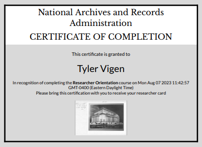
Thankfully I was already an expert in archive reading room rules and procedures due to the inordinate amount of time I had spent in the Minnesota Historical Society, so I passed the quiz with flying colors.
 so that it is clear nothing that isn't supposed to leave the facilty walks out. CC-BY Tyler Vigen 2023 (reuse allowed).")
Jake and the NARA office staff were most helpful in providing the documents from the Minnesota Department of Public Roads. The documents, on the other hand, were not nearly as helpful.
The first problem: the records for project 494-4-32 were missing!
I found project 494-4-31:
.")
And I found project 494-4-33:
.")
But I did not find the in-between project number, 494-4-32, which is the project number for my bridge! Rats!
I am simplifying a bit here, because it's not as though the ordering or naming is perfectly consistent. Project 494-4(31) was in a 1965 box separate from the others. The main run of construction along I-494, including projects (28), (33), and (36) that were built alongside the bridge I was interested were all together in a 1959-1963 box. But this is why I went down to look for myself; I pulled all the boxes that could plausibly be related, and even pulled and reviewed all boxes of MN Highway Department records from the approximate time period that were labeled 'No label' to make sure I didn't miss anything. If I was going to fly down there, I was darned well going to be thorough about it.
I found one mention of 494-4(32), but that was just a passing reference:

That document is about a nearby bridge, the Lyndale Bridge.
If you've been following along in the footnotes, this is the bridge that we previously saw being deconstructed in that 1959 newspaper article from the Bloomington Sun.
To date, this is the only reference I have found to that project number outside of the plaque that is physically mounted to the bridge.
Actually, bridges plural. 494-4-32 is also the project number on the plaques of the Portland and 12th Ave bridges. 494-4-32 seems to refer to a section of the interstate, not an individual bridge. But that doesn't change the fact that the records are missing. Also there are one or two other sheets that also have a similar reference to 494-4(32), but they are somehow even less helpful than this one.
Even if I had found the file for project 494-4-32, none of these records contain rationale for the original projects. They are basically complicated receipts and audit trails. They contain information about what was built, how much it cost, who bore the cost, and how much steel/concrete was required. They include engineering inspection reports, interviews from the workers on-site confirming they were being paid minimum wage, and even records of the specific numbers and charges for individual trees planted and removed.

This makes quite a bit of sense as a guard against fraud and corruption, and to ensure the works program provided the jobs it was designed to provide. You need this level of financial record-keeping to maintain an honest, transparent government. But who cares about that when we have a bridge mystery to solve?
So I did not learn much about why this bridge was built. But given the amount of construction audit commentary I read, at least I now know which state engineer I would want overseeing my projects if someday I become a road construction contractor in 1960.
ONE FINAL EXPERT OPINION
At this point I was convinced I had finally exhausted all lines of research. I had my case, and I was ready to lay it out. The evidence is circumstantial, but it's convincing. No one could say I didn't chase down every lead.
Just as I was about to put pen to paper and declare my findings, I happened to run into a colleague at a conference: Janel Forde. Janel is an expert in public operations management, including infrastructure projects. She served as the Deputy City Commissioner and Chief Operating Officer for the City of Chicago, and is now the Chief Operating Officer for the City of Denver.
I showed the bridge to Janel and asked how she would solve the mystery of why it was built. She told me to stop looking at old documents: "no one writes down the real reason for infrastructure projects." She said I needed to look for people in power. Specifically, if I want to prove my theory, I should look for people who would be connected to both the church and the bridge.
She also ranted about politicians' pet projects in her cities, but I will spare you the details.
So I started making a list of people in power who might meet that criteria. First on my list was Fred Kittell, who was Mayor of Richfield at the time the bridge was being planned (we ran into him earlier in that city document that just said "a discussion followed.")
The very first result from the first search I ran on that first name was this article from the Minneapolis Star in 1955:

In that article Mayor Kittell provides a list of demands from the City of Richfield to approve moving forward with the interstate. That's promising! I excitedly read on.
Among the demands from the city is this:

My very first thought after reading that was, "OH MY GOSH! THIS IS IT!!"
My second thought was, "Wait, this whole time I could have solved this mystery from my couch? I didn't have to go to St. Paul, much less Kansas City?"
With the benefit of hindsight, I am glad I didn't learn the answer on day one. I wouldn't have known that that was only the tip of the iceberg to the much deeper story!
But yes! It is hard to get more clear than "A foot-bridge should be planned at Second avenue to serve Assumption school and church." That is why the bridge is there!
CONCLUSION
If ever there was an argument to engage a functional topic expert early, this project is it! I could have saved two months
Well, a couple weekends. But who's counting? (My wife. My wife is counting.)
of research if I had talked to Janel first. I reviewed the keywords in the article to understand why it didn't come up earlier; much of the wording is ambiguous ("super-highway") or falls victim to the keyword problems we discussed before.
I searched for 'Assumption' and 'footbridge' many times, but apparently never together with the right dates included. It wasn't as obvious then as it is to me now that the bridge was planned in 1955, so a lot of my early searches were for 1958-1960. Most articles about Assumption are about times for services. This is also not the only Assumption Church in Minnesota. Anyway: many excuses, but I did not see this article until I searched it this way.
The best search terms were not road names, they were people's names.
But at least now we have a complete answer to the mystery of the Bloomfield bridge.
By the way, about these epic pics: you can't just fly a drone this close to the airport without getting in trouble with the Federal Aviation Administration. This is restricted airspace. That's why I went through the process of requesting and receiving drone flight clearance from the FAA, just so I could show you these photos. You're welcome.
.")
This pedestrian bridge—the Bloomfield bridge, MnDOT bridge #9078, the footbridge over the super-highway that was part of Federal Project 494-4-32—was built for church-goers and schoolchildren to walk to Assumption Church and School.
Approval and funding to build the bridge were enabled by the Federal Aid Interstate Act, and at the time most other pedestrian bridges in the area were built for the same purpose and funded the same way. The location of the bridge leading to Assumption church is special because it connects two communities that have been connected for over 100 years: Bloomington and Richfield. These communities were so interconnected at this spot that the city names were at one point concatenated to Bloomfield in recognition of the cohesion between the two cities, cemented by the church.
You may have missed it (because I glossed over it), but it wasn't even the Bloomington City Council that pushed for the bridge. Richfield, the city on the side that has the church, pushed for the bridge because they saw the south side of the interstate as part of their community.
While the official record is no more, at least this article can serve to tell the full story of Bloomfield bridge #9078.
One last note about the name (to avoid confusing future historians): The bridge's official name is Bridge #9078. As far as I know, I am the only one who refers to it as the 'Bloomfield Bridge.' I think 'Bloomfield Bridge' is fitting given the context from the 1800s, but that's not the official name or even a local name for it. Folks who grew up in the area sometimes refer to it as the '2nd Avenue Bridge' or the 'Footbridge to Assumption Church.'
.")